
United States Department of the Interior
OFFICE OF THE SECRETARY
Office of Environmental Policy and Compliance
Pacific Southwest Region
333 Bush Street, Suite 515
San Francisco, CA 94104
IN REPLY REFER TO:
ER# 11/948
Electronically Filed
18 January 2012
Mr. Jim Upchurch, Forest Supervisor
U.S. Forest Service
Rosemont Comments
P.O.Box 4207
Logan, UT 84323
Subject: Draft EIS, US Forest Service, Rosemont Copper Project, Proposed Construction, Operation with Concurrent Reclamation and Closure of an Open-Pit Copper Mine, Coronado National Forest, Pima County, AZ
Dear Mr. Upchurch:
The Department of the Interior has received and reviewed the subject document and has the following comments to offer:
The air quality analysis considers the air quality and Air Quality Related Value (AQRV) impacts from the proposed mine operations for all action alternatives at Saguaro National Park and Chiricahua National Monument, two Class I areas administered by the National Park Service (NPS). The National Park Service previously provided air quality comments to the USFS on the DEIS. We appreciate the changes made to the DEIS to incorporate text from the technical modeling reports.
However, we have several outstanding concerns, including the predicted AQRV impacts (visibility and nitrogen deposition) in nearby Saguaro National Park. We appreciate the U.S. Forest Service for evaluating additional mitigation options to address the AQRV impacts and the National Ambient Air Quality Standards (NAAQS) attainment concerns, and welcome the opportunity for further interagency discussion and public discourse on these important matters. Comments concerning other potential impacts to Saguaro National Park and surrounding resources are also included.
Table 31 and 32: Project Emissions and Background Monitoring Data
Table 31 provides emissions for criteria pollutants resulting from the proposed action for year 1 and year 5 of mining operations. Table 32 also provides the same information, but for all action alternatives (including the proposed action). The NO x emissions reported for the proposed action alternative in Table 31 are inconsistent with the NO x emissions reported for the same alternative in Table 32; this suggests there is an error in one of the tables.
Table 29 provides monitoring data from nearby PM 10 monitors in Pima County, Arizona; maximum 24-hour PM 10 values range from 79-146 micrograms per cubic meters (ug/m 3 ). Based on information provided later in the DEIS, we understand Rosemont conducted on-site PM 10 monitoring; the most recent three years of on-site PM 10 monitoring data from this site should be included in Table 29. Further, rather than reporting just the maximum PM 10 concentration at a single monitor in given year, the most recent three-year average of the annual high second high PM 10 concentrations should be reported in this section of the DEIS for all stations in the air analysis area, including the on-site monitor, as this reflects the computation methodology for PM 10 NAAQS demonstrations.
Similarly, the concentrations reported for all pollutants should reflect the computation methodology used in a NAAQS demonstration for the specific pollutant for all monitors in the air analysis area (i.e., for 8-hour ozone, the most recent 3-year average of the annual 4 th max 8-hour value for all monitoring sites in the analysis area should be reported). We recommend including this information in the Final EIS to give the reader a better understanding of the regional air quality status relative to the NAAQS.
Table 34 and 35: NAAQS Demonstration Modeling Results
Tables 34 and 35 in the DEIS present the modeling results for the criteria air pollutants, and the NAAQS demonstration results for each of these pollutants for emissions years 1 and 5 at the project site. In reference to the background 24-hour PM 10 concentrations used in the NAAQS demonstration, the DEIS states, �based on the Applied Environmental Consultants review of the PM 10 concentration data and the large differences between the highest measured value
(71.3 ug/m 3 ) and the second highest value (40.3 ug/m 3 ), a statistical analysis was conducted on all data to determine its probability of occurrence. This analysis is provided within Appendix C of the �Modeling Protocol to Assess Ambient Air Quality Impacts� for the project (Applied Environmental Consultants 2009b).
The statistical analysis indicates that the probability of occurrence of 71.3 ug/m 3 is 5.9 × 10⁻¹¹. This low probability indicates 71.3 ug/m 3 is an outlier to the distribution and should not be included in the determining the background concentration. Therefore, the 24-hour background PM 10 concentration was based on the average of 27.0, 40.3, and 31.6 or 33.0 ug/m 3 .� However, these background values are much lower than the monitored values reported for 24-hour PM 10 in Table 29 of the DEIS.
We recognize the background concentrations were derived from statistical analysis of on-site data not provided in Table 29. However, we recommend the DEIS provide additional justification and detail regarding how background particulate concentrations used in the on-site NAAQS compliance demonstrations were selected. Further, the DEIS should address how the background PM 10 concentration used in the NAAQS demonstration conform to the Arizona Department of Environmental Quality (ADEQ) methodology of calculating background PM 10 concentration.
Similarly, in Table 29, the background concentrations used in the PM 2.5 NAAQS demonstration are much lower than the concentration values reported for near-by monitors. We question the use of PM 2.5 monitored data from Petrified Forest National Park when there are closer PM 2.5 monitoring sites. We recommend the DEIS provide additional justification for the background PM 2.5 concentrations used in NAAQS compliance demonstrations.
Tables 36 and 37 present the modeling results for the criteria air pollutants, and the NAAQS demonstration results for each of these pollutants for emissions years 1 and 5 at Saguaro National Park. As with the on-site NAAQS demonstrations, background values utilized in the analysis for PM 10 and PM 2.5 are much lower than the values reported for near-by monitors in Table 29. We recommend the DEIS provide additional justification and detail regarding how and from what monitor the background particulate concentrations used in the Saguaro NAAQS compliance demonstrations were selected.
Page 181 of the DEIS describes the AERMOD modeling to evaluate effects to the 1-hour NO 2 standard. In order to evaluate NO 2 concentration impacts, a NO 2 to NO x conversion ratio must be assumed in the modeling analysis; as identified in previous comments, the ratios used in the DEIS do not reflect the most recent U.S. Environmental Protection Agency (EPA) Guidance for modeling for the 1-hour NO 2 NAAQS . The DEIS AERMOD modeling for the 1-hour NO 2 NAAQS should either follow the EPA Clearinghouse memo (Additional Clarification Regarding Application of Appendix W Modeling Guidance for the 1-Hour NO 2 National Ambient Air Quality Standard, March 1, 2011), or provide additional justification and results of in-stack testing data within the DEIS demonstrating why the EPA-recommended ratios are not appropriate to use in the Rosemont modeling.
Class I Area AQRV Impacts
Visibility
Tables 43 through 45 report the modeled near-field and far-field visibility impacts for Class I areas included in the analysis for two emission years. A near-field analysis was completed for Saguaro East, the closest Class I area to the project. A far-field visibility analysis was completed for all other Class I areas in the analysis area greater than 50 kilometers (km) from the proposed mine site, including Saguaro West National Park and Chiricahua National Monument.
The Level 1 and Level 2 VISCREEN results predict that FLM thresholds for change in color will be exceeded against a terrain background at Saguaro East for F stability and a wind speed of 2.0 meters per second. The far-field modeling results predict a change in visibility over 0.5 deciview (dv) for 21 days in emission year 1 and 24 days in emission year 5, and one day over 1.0 dv change in both emission years at Saguaro NP. Under EPA definitions in the Best Available Retrofit Technology (BART) guidelines for the Regional Haze Rule, the Rosemont mine would be considered to �cause� visibility impairment in this class I area.
As stated in previous comments, visibility impacts of this magnitude are significant concern to the DOI, and because Saguaro National Park will not meet the Regional Haze goals under the ADEQ- proposed Regional Haze State Implementation Plan. Regional modeling completed for the regional haze process demonstrates visibility on the 20 percent best visibility days at Saguaro NP will degrade in the future. The goal of the regional haze program is to improve visibility on the 20 percent worst days and prevent degradation on the 20 percent best days. The modeled impacts from the project will further exacerbate an existing problem. As outlined below, the NPS would like to be involved in any subsequent mitigation analyses and discussions to ensure visibility impacts are adequately addressed.
Finally, there appears to be a discontinuity between the modeled maximum concentrations for Chiricahua National Monument reported in Table 8.3 of the April 4, 2011 CALPUFF Modeling Report, and the predicted visibility impacts presented in Table 9.1. In reviewing predicted concentrations Tables 8.1 and Table 8.3 at Saguaro West and Chiricahua National Monument respectively, the predicted maximum short-term concentrations of visibility impairing pollutants are much higher at Chiricahua National Monument than Saguaro National Park West.
However, the visible haze impacts at Saguaro National Park West are much higher than the impacts at Chiricahua National Monument. The values in these three tables should be checked to ensure the correct impacts are reported for the two NPS areas, or whether there is an anomaly in the maximum predicted concentrations at Chiricahua National Monument.
Nitrogen Deposition
We are concerned about the predicted nitrogen deposition in Saguaro National Park, which is predicted to exceed the NPS Deposition Analysis Threshold (DAT) by almost a factor of 5. The DAT represents a significance threshold, used to determine whether the predicted deposition impacts warrant further evaluation in light of current ecosystem conditions.
When the DAT is exceeded, we examine whether the ecosystem(s) in the park are sensitive to and potentially affected by deposition.
In this case, we are concerned desert and semi-arid ecosystems, such as those in Saguaro National Park, may be impacted by current levels of nitrogen deposition. Recently published research for other arid areas has indicated nitrogen deposition stimulates productivity of exotic grass species and induces other changes in natural species composition. This suggests natural ecosystems in Saguaro National Park may be at risk for invasion by exotic grasses (cheatgrass) along with accelerated invasion of the already present buffelgrass due to increased nitrogen deposition.
Nitrogen deposition in these areas has also been shown to increase fire frequency from enhanced fuel loading of grasses which can decrease the native plant composition and eliminate Sonoran Desert plant communities. There are also cultural resources in this area that could be at risk if fire frequency increases.
The Four Corners Region has experienced long-term deposition from large sources of nitrogen emissions, including stationary point sources and significant growth in the area source sector from regional oil and gas development. Accordingly, a recent risk assessment evaluating the sensitivity of numerous NPS areas to nutrient enrichment effects from nitrogen deposition ranked Saguaro National Park at a high risk to impacts from nitrogen deposition.
Site-specific research has not been conducted in Saguaro National Park to determine the degree in which nitrogen deposition may be impacting vegetation, including the extent, species composition, or fuel loading of grasses. However, the existing evidence and the nitrogen risk assessment results for Saguaro National Park suggest nitrogen deposition is a significant concern. Therefore, the magnitude of the modeled DAT exceedance due to emissions from the Rosemont mine is a significant concern. Therefore, we recommend a discussion of these concerns in the analysis, including a disclosure of NPS findings. As outlined below, any subsequent mitigation discussions should also consider nitrogen deposition impacts.
Mitigation Effectiveness
The Mitigation Effectiveness section in the DEIS provides a description of mitigation options considered in the analysis, along with additional mitigation measures under consideration by the USFS. The DEIS states the additional mitigation measures are currently being evaluated and modeled due to the predicted NAAQS compliance issues and the AQRV impacts in near-by Saguaro National Park.
We believe additional mitigation should be included to reduce visibility impairing pollutants and nitrogen deposition at Saguaro National Park. Therefore, we recommend the list of additional mitigation measures focus on controlling particulate emissions and NO x emissions. If feasible, further NO x reductions should be considered.
We encourage the USFS to work collaboratively with the NPS in developing these additional mitigation strategies to ensure NPS concerns are adequately addressed.
Finally, the DEIS states the �modeling of the additional mitigation measures with be conducted during the interim period between the issuance of the DEIS and the publication of the FEIS.� It is unclear from this statement whether the USFS intends to release this additional information in draft form for public review prior to publication of the Final EIS. Once completed, we encourage the USFS to release this information for public comment and review prior to Final EIS publication.
Saguaro National Park
Plants and Wildlife
The long-term viability of the plant and animal species present within Saguaro National Park depend on the quality and abundance of habitat both outside and inside of the park boundaries. Many species such as the lesser long-nosed bat are migratory and utilize the resources of the park during certain times of the year (roosting in the later summer and fall). Riparian corridors are scarce in the desert southwest and therefore the existing springs, seeps, and watersheds are important and should be protected or enhanced.
Additionally, the project could reduce surface water discharge from Cienega Creek and Davidson Canyon, which contains habitat for many local and migratory species. There could be a loss of at least 490 acres of riparian corridor habitat and expected loss of up to 63 springs and seeps. We are concerned the project could further fragment wildlife habitats and reduce connectivity between habitats of migratory and resident bird populations. Therefore, we recommend migration corridors maintain their integrity and continue to offer ecosystem processes for these species.
The analysis within the Affected Environment and Environmental Consequences section of the DEIS is limited in terms of describing direct and indirect effects to plant animal species that may be dependent on the project area resources. The determination of effects does not adequately describe the effects of dependent species at the local population level and only states either some impacts may occur or the species will not be affected at the extant population level. Therefore, we recommend the USFS conduct further analysis of effects at the sub-population level and disclose local effects of the project within and adjacent to the project area.
Due to project implementation, we are also concerned about the introduction and increased abundance of invasive nonnative plants. The DEIS states, �disturbed areas would be revegetated and monitored for reclamation success.� However, the duration and method of this monitoring is not discussed. Specifically, what will be done to ensure success of revegetation efforts and how will the proponent be responsible for success? The reestablishment of native vegetation and control of invasive nonnative species are critical to the long-term health of public lands. A full explanation of realistic expectations of the required revegetation efforts is needed in order to demonstrate the scale of this undertaking and the inherent complexities of successful remediation.
Further, page 71 of the DEIS states Rosemont Copper commenced revegetation studies in 2007 to ensure any revegetation program used would be successful. The DEIS does not indicate any type of results this study yielded. In relation to existing conditions, what was the post-study percent cover of native plants and invasive weeds? Revegetation of the tailings piles and other disturbed areas is imperative to reducing fugitive dust and replacing lost vegetation.
We recommend the Final EIS demonstrate revegetation and weed control efforts will actually be successful in this harsh environment.
Endowment Trust
On page 66, the establishment of the Santa Rita Mountains community endowment trust is presented. As described in the DEIS, this section offers no assurance endowment funds will support cultural and/or environmental conservation. Therefore, we recommend the USFS require specific measures (such as off-site mitigation) to directly benefit any impacted resources.
Monitoring
As described on page 79, post closure monitoring would occur for an undetermined period of time. There are no assurances monitoring will occur as needed unless there is at least a minimum duration established in advance. Therefore, we recommend the Final EIS describe the permit conditions or other binding requirements to ensure monitoring will continue for the length of expected impacts from this project.
Task Force
On page 64 of the DEIS, this section describes an Interagency Task Force, but does not give a description of the task force's latitude to influence the operation once started and any limitations of its authority on the project operations. Therefore, we recommend the Final EIS describe under what authority the proposed task force responsible for monitoring the project would operate.
Forest Plan Amendment
The Forest Plan Amendment described on pages xix, 90, and 93, would allow mining activities on USFS lands where they would result in non-adherence to the approved Forest Plan. We do not support making amendments to the existing approved and publically vetted plan that would lead to a degradation of air quality at Saguaro National Park and decreased environmental protection of the Santa Rita Mountains which are integral to the overall health of this region of the Sonoran Desert.
Cumulative Effects
The list of foreseeable actions presented in the Cumulative Effects section on page 413 and elsewhere should include other mining considered in the Santa Rita Mountains. Therefore, we recommend the Final EIS consider any additional mining in the cumulative effects analysis for all resource and environmental parameters.
Chapter 3, Affected Environment and Environmental Consequences, Volume 1,
Page 205: Groundwater Quality
General :
The mine site groundwater-flow models by Montgomery and Associates and Tetra Tech use the same or a similar lateral domain, with different layering and different aquifer properties. In both models, most of the lateral boundaries are �artificial,� not representing actual physical hydrologic boundaries.
The Montgomery and Associates model uses a combination of constant-head and general-head boundary cells on much of the lateral model domain, and the Tetra Tech model uses constant-head cells on much of the model perimeter. Reilly and Harbaugh (2004) indicate, �when physical hydrologic features that can be used as boundary conditions are far from the area of interest, artificial boundaries are sometimes used.
The use of an artificial boundary should be evaluated carefully to determine whether its use would cause unacceptable errors in the model.� In discussing use of models to calculate �capture� or depletion of connected features such as surface water, Leake et al., (2010) state, �a model should include all head-dependent boundaries representing features from which capture can occur but should not include artificial or unrealistic head-dependent features� that might affect computed capture at realistic head-dependent flow boundaries.�
They further state, �artificial model boundaries are problematic in calculations of capture because they can affect calculation of capture from actual physical features represented with head-dependent boundaries. If artificial model boundaries exist, care must be taken to limit the extent of the capture map to locations where capture is almost entirely from head-dependent flow boundaries that represent physical features.�
Earlier reports by Leake and Reeves (2008) and Leake et al. (2008) offer similar cautions on use of artificial boundaries in models where capture of surface water and evapotranspiration is computed and discuss testing of possible influence of artificial boundaries on calculations of capture. Neither the Montgomery nor the Tetra Tech mine site model documentation reports discuss any tests to understand possible errors related to the artificial boundaries, as suggested by Reilly et al. (2004), Leake and Reeves (2008), and Leake et al. (2008). Therefore, we recommend possible effects of artificial boundaries be tested in both site models. A simple and inexpensive test could be conducted for each of the two site models as follows:
• For the steady-state model, record net model-computed flow to (a) artificial head-dependent boundaries, and (b) to head-dependent boundaries representing real features (springs, streams, and evapotranspiration areas).
• Make a second run of the steady-state model, this time with a constant rate of pumping by a well at the site of the proposed mine. The pumping rate should be large enough so that pumping-induced changes can be resolved above normal mass-balance error in the model.
• Compare net flow rates from the two model runs to get pumping-induced changes in head-dependent boundaries separately for artificial model boundaries and for real features.
In the results outlined in step 3, effects of the extraction on head-dependent boundaries representing actual features including perennial streams, springs, and phreatophytes, should be much larger than effects of the extraction on artificial head-dependent boundaries on the perimeter of the model. For the purposes of looking at capture over large areas, Leake and Reeves (2008) suggest the change in net flow to artificial boundaries divided by the pumping rate of the added well be less than 0.1 (10 percent of the pumping rate).
If this test indicates effects of extraction of water at the site of the mine is potentially influenced by the chosen artificial boundaries, we recommend additional modeling be carried out to better understand possible effects of mine activities on connected streams, springs, and phreatophytes.
In evaluating possible effects on more distant features, such as lower Cienega Creek, use of a detailed mine site model probably is not the best approach. Instead, a more regional model with real boundaries (or artificial boundaries that do not affect calculations of capture) is preferable. Possible approaches are as follows:
• Expand the Tucson AMA model to include the bedrock aquifer adjacent to the basin-fill aquifer currently modeled.
• Construct a superposition or �change� model that represents estimated hydraulic diffusivity in the bedrock aquifer and adjacent valley-fill aquifers. Hydraulic properties from existing mine site models and the Tucson AMA models could be used.
• Construct a new flow model that does not have artificial boundaries that can affect the calculation of capture.
Another possible concern relating to artificial head-dependent boundaries is they can overly constrain the solution for model heads, the primary variable used for model calibration. Reilly and Harbaugh (2004) indicate, �artificial boundaries, if applied improperly and not evaluated, can overly constrain the response of the system and bias the results of an analysis.
A frequently observed example is when the area of interest for a study is artificially bounded by specified heads, without regard to the flow being simulated from this boundary into the study area. In this case, the model may not be sensitive to parameter values and stresses because the specified heads artificially keep the simulated heads from deviating much.� Therefore, we recommend possible effects of artificial boundaries on model calibration be discussed in detail.
Page 212, Summary of Models Used: The DEIS states, �Rosemont Copper commissioned Tetra Tech to prepare a second, completely independent groundwater flow model of the mine site.� The Tetra Tech model of the mine site does not appear to be �completely� independent of the Montgomery and Associates mine site model. Both models use the same lateral domain and positions of artificial boundaries and some of the same flow components, such as evapotranspiration. We recommend correction of statements in the DEIS that characterize these as �completely independent� models.
Pages 225-227: Table 47, Summary of Effects: These comments are related to all Issue Categories and Subcomponents for the Davidson Canyon/Cienega Basin.
Any predictions of the short-term (mine operation) and long-term (permanent pit) effects of the mining activities, both on water levels in specific areas and spring and stream flow at specific surface water features, require information about aquifer properties including the distributions of aquifer transmissivity and hydraulic conductivity, aquifer storage properties, and interconnections of permeable faults and fractures.
The ultimate long-term effect on groundwater discharge to all springs and streams is well defined by the overall change in the groundwater budget resulting from the permanent mine pit and accompanying lake. This long-term assessment requires no estimates of aquifer properties. However, predictions of the distributions of water-level changes and groundwater discharge to springs and streams require a well parameterized groundwater flow model.
Significant efforts have been made to estimate the transmissivity and hydraulic conductivity of various rock units. However, no information regarding aquifer storage properties is provided in the Phase 2 Hydrogeology Report of Montgomery and Associates. As a result, it is unknown how aquifer storage properties were distributed in the groundwater flow models.
Aquifer storage properties require better definition before any models can attempt to reliably predict water-level changes in specific areas or changes in flow to any specific springs and streams. Unfortunately, aquifer-storage properties are difficult to obtain without long-term monitoring of aquifer response to well documented withdrawals.
Alternatively, groundwater flow models could assume aquifer storage properties that result in a worst-case scenario of predicted water-level change and reduced groundwater discharge to springs and streams. Long-term monitoring of the aquifer response to the mine development can help ascertain the aquifer storage properties.
The Phase 2 Hydrogeology Report of Montgomery and Associates documents the occurrence of highly permeable fault and fracture zones in the otherwise low-permeability rocks throughout the mine vicinity. Any interconnectivity of these highly permeable features will significantly affect future changes water-level and discharge to springs and streams.
Unfortunately, little is known of the interconnectivity of these permeable features and accordingly, the available groundwater flow models of the area do not explicitly simulate flow in these features. Only long-term monitoring of the aquifer response to large stresses, such as the mine development, will help reveal the interconnectivity of highly permeable faults and fractures.
Page 253, Effect on Land Subsidence: Land subsidence in the Upper Santa Cruz basin resulting from development of the mine water supply does not appear to have been evaluated. An assessment of land subsidence related to development of the mine water supply requires estimates of aquifer-system compressibility and simulation using a groundwater flow model.
In the development of the Mine Water Supply Model, the existing Arizona Department of Water Resources groundwater flow model was not modified to include the ability to simulate aquifer-system compaction and land subsidence. Inclusion of the subsidence capability in the model would also likely require the simulation of seasonal groundwater withdrawals for the purpose of assessing the large seasonal variations in water levels observed in the Sahuarita area. We recommend the DEIS include an evaluation of land subsidence and that subsidence monitoring be conducted during and after the period of groundwater withdrawals.
Page 287, Expected Water Quality, Tailings Facility: This comment is based on a review of Infiltration, Seepage, Fate and Transport Modeling Report (section 6.3.3, pages 76 � 78; section 6.4.3, pages 84 � 85).
The detail provided on the PREEQC model is insufficient to understand the accuracy of the predicted chemistry of the tailings seepage (Table 64). How much alkaline material (limestone) was included in the PHREEQC model of the tailings stack? The resulting pH from the model for the seepage solution from the tailings is 5.87, which is more neutral than most tailings seepage in southern Arizona. The relatively high modeled pH is most likely controlling the low metal concentrations in the predicted tailings seepage. We recommend the Final EIS include sufficient detail for readers to understand the accuracy of the predicted chemistry.
Page 288, Expected Water Quality, Tailings Facility: This comment is based on a review of Infiltration, Seepage, Fate and Transport Modeling Report (section 6.3.1, pp 71 � 74; section 6.4.1, pages 78 � 80).
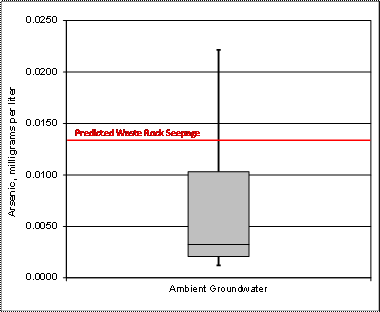
Figure 1. Sampled arsenic concentrations in groundwater (M&A, 2009) and predicted arsenic concentration in Waste Rock Seepage (EIS).
The DEIS states, ��the predicted arsenic concentration of 0.013 milligrams per liter (mg/L) is generally in the range naturally observed in ground water samples within the project area (<0.005 to 0.0266 mg/L). Furthermore, Table 65 in the DEIS states an ambient groundwater quality for arsenic of 0.0037 mg/L.� According to Table 7 in Results of Phase 2 Hydrogeologic Investigations and Monitoring Program Rosemont Project, Pima County, Arizona (Montgomery & Associates, 2009), the DEIS cites the correct ambient arsenic concentration range for the groundwater samples collected by Montgomery & Associates, and Table 65 in the DEIS gives the approximately correct average (or 50 th percentile) ambient arsenic concentration range for the groundwater samples collected by Montgomery & Associates (a concentration of 0.0037 mg/L is given; the average ambient concentration is actually 0.0033 mg/L as reported by Montgomery and Associates).The predicted arsenic concentration for the Waste Rock Facility seepage, however, is not �generally in the range naturally observed in ground water samples within the project area.� The predicted arsenic concentration for seepage from the Waste Rock Facility is in the 78 th percentile of the arsenic values reported by Montgomery and Associates, and is 0.0097 mg/L higher than the average sampled groundwater concentration (Figure 1).
Similarly, the report Infiltration, Seepage, Fate and Transport Modeling Report (Tetra Tech, 2010) states on page 80 ��groundwater at the site shows the influence of mineralized background geology in several wells. Twelve of the wells and springs sampled at the Project site contain arsenic in concentrations above the estimated value derived from the geochemical mixing and equilibrium model and above the proposed AWQS (0.011 mg/L to 0.027 mg/L).�
The twelve wells and springs with arsenic concentrations above the AWQS, however, only represent 34% of the sampling locations. The Infiltration, Seepage, Fate and Transport Modeling Report (Tetra Tech, 2010) and the EIS, however, fail to mention that, according to Table 7 in Results of Phase 2 Hydrogeologic Investigations and Monitoring Program Rosemont Project, Pima County, Arizona (Errol L Montgomery & Associates, 2009), there were 35 wells and springs (or 66% of the locations sampled) with arsenic concentrations below the AWQS.
In addition, two of the twelve wells and springs which had samples with arsenic concentrations above the AWQS were sampled more than once; the repeat samples had arsenic concentration below the AWQS (Errol L Montgomery & Associates, 2009, Results of Phase 2 Hydrogeologic Investigations and Monitoring Program Rosemont Project, Pima County, Arizona ). Furthermore, there was an order of magnitude difference between the highest and lowest arsenic concentrations at each of these two locations.
The document does not contain the information needed to determine the groundwater quality sampling quality control procedures or the quality assurance of the data. We recommend the Final EIS include sufficient information to evaluate the sampling and quality.
Page 288, Expected Water Quality, Heap Leach Facility: This comment is based on a review of Infiltration, Seepage, Fate and Transport Modeling Report (section 6.3.2, pages 74 � 76; section 6.4.2, pages 81 � 84).
The predicted Heap Leach Facility Seepage, modeled with PHREEQC, (Table 66 in the DEIS and Table 6.8 in Infiltration, Seepage, Fate and Transport Modeling Report (Tetra Tech, 2010)) has a pH of 3.23 and a dissolved oxygen concentration of 7.47 mg/L. Typically, drainage with this low of a pH would have a lower dissolved oxygen concentration because of the oxygen demand of oxidation-reduction reactions.
The DEIS does not included sufficient information to determine the validity of the PHREEQC model for the Heap Leach Facility. We recommend the Final EIS include sufficient information to evaluate the validity of the model.
Page 296, Surface Water Quality
General :
The characterization of surface-water quality should include a detailed analysis of baseline conditions in the upper mountain watershed in the immediate area of the mine pit, Davidson Canyon, and Cienega Basin. Although flow discharge estimates from Barrel and Scholefield Canyon waters were cited at approximately 900 to 1,500 acre-feet per year (Hargis and Harsharger (1978), no comparative load calculations are estimated.
Likewise, baseline water quality conditions for Cienega Creek from upstream of the Davidson Canyon junction should be clearly defined as well as downstream of the junction. Characterization of Cienega Creek should most likely be extended past the confluence of Empire Gulch. Evaluation of expected water-quality conditions during mining is difficult to assess without adequate pre-mining characterization in place. On-going monitoring of surface-water quality should be planned throughout mine operation to assess changes.
Page 33, Figure 50, Potential jurisdictional waters of the United States: Figure 50 is referenced but it does not display specific areas described in this section. This includes sub-watershed boundaries, particularly Barrel, Wasp, McClearly, and Davidson Canyon; also the 494.4 acres designated as Important Riparian Area with the proposed site. Perennial and intermittent flow areas should be delineated, either on Figure 50 or on a separate figure.
A spring site, Reach 2 Spring, is referenced (page 332) and should be located on a map with other sample points discussed in this section. We recommend the Final EIS include these items on the figures. In addition, Reach 2 Spring could not be located on table provided in groundwater-quantity section.
Pages 332-334, Table 90, Results of baseline water quality samples:
• Sample points should be shown on map figure.
• Significant parameters, pH, conductivity, total dissolved solids, alkalinity, turbidity, dissolved oxygen, and anion (SO 4 ) - concentrations are missing from the table.
• Describe method of analysis.
• The large discrepancy between dissolved and total metals should be explained. The total metals concentration of copper, lead, zinc, and nickel appear to exceed or approach an order of magnitude difference from dissolved values and could therefore include suspended sediment, colloidal particulate matter, or chemical precipitate with adsorbed metals (Aluminum, Copper, Lead, and Zinc). In any case, pH, conductivity, turbidity, etc., are essential to characterize the water quality within the proposed site.
It appears Empire Gulch, Oak Tree Canyon, and North Canyon should be included in the baseline characterization of the area.
Pages 226-339, Sediment yield: The DEIS does not identify the modeling program used to calculate sediment delivery.
Pages 339-341, Potential for Acid Rock Drainage: The initial paragraph states, �Acid rock drainage occurs naturally in the environment at a very slow pace��. The actual acid rock drainage conditions need to be quantified throughout the designated site. A map of known sulfide distribution/alteration zones in the proposed mine site/mineralized area should be displayed in this section. Perhaps a geologic cross section placed further south across the mine pit area could generally illustrate sulfide distribution, alteration, and the placement of the porphyry in the system.
The current cross section, located in the geology section, does not, but should display the mineralizing porphyry or alteration distribution in the mine site. In addition, the document does not identify where the acid base accounting samples were taken, and it is unclear whether these were surface samples or included core samples. We recommend the Final EIS include the information to address these issues.
Chapter 3, Affected Environment and Environmental Consequences, Volume 2
Pages 355, 370, and 376 : The desert tortoise has recently been split into two species. The newly recognized species has been named Morafka's desert tortoise ( Gopherus morafkai ) and represents populations naturally found east and south of the Colorado River, from Arizona extending into Mexico. The originally recognized species, the Agassiz's desert tortoise ( Gopherus agassizii ) is listed as threatened under the federal Endangered Species Act.
It represents populations naturally found west and north of the Colorado River in Utah, Nevada, northern Arizona and California. Morafka's tortoise prefers to hide and burrow under rock crevices on steep, rocky hillsides, while the Agassiz's tortoise prefers to dig burrows in valleys. We recommend the name be corrected in the Final EIS.
We appreciate this opportunity to provide comments on the Rosemont Copper Project, and we look forward to continuing our work with the USFS in developing the DEIS.
Sincerely,

Patricia Sanderson Port
Regional Environmental Officer
Cc:
Director, OEPC
Cheryl Eckhardt, National Park Service
Regional Director, Fish and Wildlife
Gary LeCain, U.S Geological Survey